
River cruising in France
France's navigable waterways
- Explore France ►
- Essential pages
- Travel in France
- Where to go
- What to see and do
About-France.com
- a connoisseur's guide to France
Cruising on the canals and rivers of France
Until the 1990s, while navigable rivers in the UK and Holland were already saturated in parts by cabin cruisers, narrow boats, and other rivercraft, French rivers were largely deserted. And relatively speaking, that remains true to this day. As well as all its other tourist attractions and opportunities, France also offers an incredible array of opportunities for anyone looking for the calm and slow life of a holiday on the water. And what's more, there are opportunities for boating holidays virtually all over France, including on rivers that have been reopened to navigation in recent years.
France has almost 8,000 kilometres of navigable inland waterways; many of these are only open to small pleasure craft, but over 3,000 km are accessible to cruise boats of varying sizes. Large river cruise boats operate on the Seine, the Rhone and the Rhine, while smaller more intimate cruises, as well as self-drive cabin cruisers, are available on many other rivers and canals.
Main French river cruises
River cruises are available in several parts of France; but there are four principal routes for river-cruising in France: they are all served by ► Avalon Cruises, a UK based river cruise specialist offering cruises throughout Europe.- Cruises on the Seine upstream and downstream from Paris
- Cruises up and down the Rhone and Saône, from Chalon sur Saône to Avignon, via Lyon,
- Rhine cruises up to and down from Basel, a Swiss city on the French border, taking in Strasbourg. And
- Gironde cruises, taking in wine-growing areas round Bordeaux.
Smaller local operators run cruises on other rivers, in particular higher reaches of the Seine and Yonne, the Saone and Doubs, the Moselle and connecting canals. Large cruise boats cannot navigate on these waterways, mostly in the east of France, as they have locks built to the historic Freycinet gauge, a width of 5.05 metres or 16ft 6 inches. While considerably larger than the narrow-boat gauge used on most canals in the United Kingdom, the Freycinet gauge was not designed for the type of cruise boats seen on the Rhine, the Rhone or other major European rivers.
Cabin cruisers can be hired at several locations on these waterways, and on the Brittany waterway network.
The regions and waterway networks:
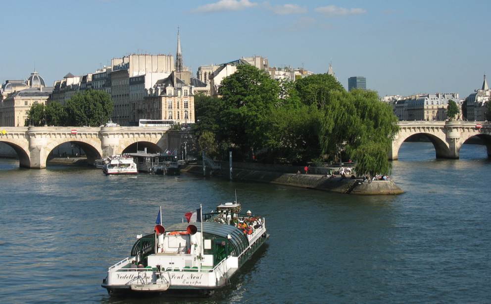
The most extensive network of waterways for boating holidays in France is in central eastern and northeastern France. Anyone who has visited Paris will have noticed how busy the Seine is, not just with barges, but also with tour boats and holiday cruisers. But Paris is just one important point on an extensive network of waterways stretching throughout the eastern regions of France.To the north of Paris, the Seine is a busy waterway, connecting with France's main port of le Havre.
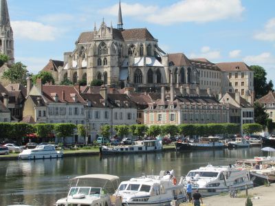
The Yonne at Auxerre
In Eastern France, a dense network of canals links the main rivers, many of which are navigable for many miles. The Saone and the Doubs rivers are particularly attractive, and also connected to the Rhine and to the Marne, allowing holidaymakers to discover the rural charm of regions such as Franche Comté and Lorraine, which are often well off the beaten track as far as traditional tourism is concerned.
 In the south of France,
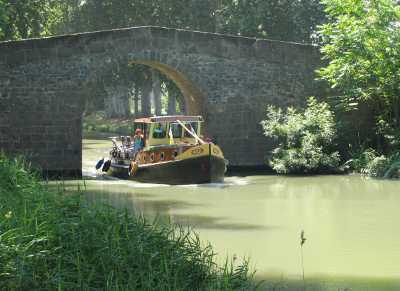
there is one network of canals that is particularly famous, and that is
the Canal des Deux Mers,
which includes the Canal
du Midi, linking the Atlantic to the
Mediterranean. A UNESCO world heritage site, this is the oldest major
operating canal system in the world, completed in 1681. It passes
through southwest France, linking Bordeaux on the Garonne to
Béziers
and the Mediterranean coast of the Languedoc
region,
by way of attractive places such as the walled city of Carcassonne.
In the south of France,
there is one network of canals that is particularly famous, and that is
the Canal des Deux Mers,
which includes the Canal
du Midi, linking the Atlantic to the
Mediterranean. A UNESCO world heritage site, this is the oldest major
operating canal system in the world, completed in 1681. It passes
through southwest France, linking Bordeaux on the Garonne to
Béziers
and the Mediterranean coast of the Languedoc
region,
by way of attractive places such as the walled city of Carcassonne.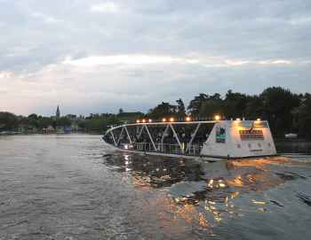 Western France
offers a selection of disconnected navigable rivers - or, to be more
precise, - navigable rivers that have disconnected sections
or are only connected by way of the coast. Among popular waterways in
western France are parts of the river Lot, the river Charente (over 150
navigable kilometers, up as far as Angoulême), or the
Sèvre Niortaise.
The lower reaches of the Loire are navigable, but the river
is not a popular boating area. In the Loire valley, there
are two popular boating areas. Firstly
the Erdre (which meets the Loire at Nantes), and connects to Vilaine and the the
Brittany waterway network; secondly the Sarthe / Oudon / Mayenne
network,
north of Angers.
Western France
offers a selection of disconnected navigable rivers - or, to be more
precise, - navigable rivers that have disconnected sections
or are only connected by way of the coast. Among popular waterways in
western France are parts of the river Lot, the river Charente (over 150
navigable kilometers, up as far as Angoulême), or the
Sèvre Niortaise.
The lower reaches of the Loire are navigable, but the river
is not a popular boating area. In the Loire valley, there
are two popular boating areas. Firstly
the Erdre (which meets the Loire at Nantes), and connects to Vilaine and the the
Brittany waterway network; secondly the Sarthe / Oudon / Mayenne
network,
north of Angers. The Brittany waterways network is centered on the small town of Redon, where the north south link, cutting right across Brittany from the Rance to the Vilaine, crosses the east-west link from Nantes to Lorient, by way of the still-existing section of the Britanny coastal canal. Contrary to information shown on certain maps and websites, this canal is no longer navigable from end to end.
Click this link for a map of the rivers of France.
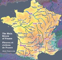
Map of French rivers. Click on the map for full-page version .
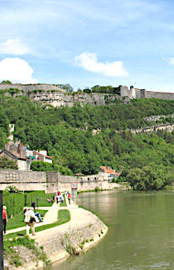
The river Doubs, beside historic Besançon
Related:
Photos on this page.
Top, the Seine at Paris, below River Yonne at Auxerre,
Middle the Canal du Midi, bottom: dinner cruise on the Erdre,
Photos About-France.com.