The rivers of France
Main
rivers and other waterways
About-France.com
- the connoisseur's guide to France
- Discover France ►
- Essential pages
- Travel in France
- Where to go
- What to see and do
►
You are here :
France
› the rivers of France
| ► Thematic index | River cruises in France | French rivers map |
| Main rivers in France | Main canals in France |
The principal rivers of France and other waterways
 |
 |
The French have two words for a "river"; a substantial river that flows to the sea is known as "un fleuve", and all other rivers - including all rivers that are tributaries of other rivers - are known of as "une rivière". Most of the French départements (counties), such as the Saône et Loire, are named after one or two rivers flowing through them. There are thousands of rivers in France; the table below lists only the main or best-known of them - notably those that have given their name to a département. The second table lists the main navigable canals in France.
Below you will find summary details of the main river basins in France.
Column 1 lists the great "fleuves" of France; column 2 shows their main tributaries, and column 3 lists significant rivers that are direct or indirect tributaries of the rivers in column 2.
Many of the rivers in columns 1 and 2 are navigable over a considerable part of their length. Click here for details of navigable rivers and river cruises in France
| River / flowing into: | Main tributaries | Indirect tributaries |
|---|---|---|
| ENGLISH CHANNEL (La Manche) | ||
| Somme (263 km) - | ||
| Seine (776 km ) - Flows through Paris | Eure | |
| Oise - (302 km) Rises in Belgium | Aisne | |
| Marne - (514 km) connected to the Saone and the Rhine by canals. | ||
| Yonne - Connected to the Loire by the Canal du Nivernais, and to the Saône by the Canal de Bourgogne. | ||
| Aube | ||
| ATLANTIC | ||
| Vilaine (218 km) | ||
| Loire
(1012 km ) the longest river completely in France. Rises in the
Ardèche. Flows through Orleans, Tours and Nantes. See regional guide for the Pays de la Loire and Centre regions |
Erdre | |
| Vienne (363 km) | Creuse, Gartempe | |
| Maine | Mayenne, Sarthe (313 km), Loir. | |
| Cher (396 km) | ||
| Indre (271 km) | ||
| Nièvre | ||
| Arroux | ||
| Allier (421 km) | Sioule, Allagnon | |
| Sèvre Niortaise (158 km) | ||
| Charente (381 km): | ||
| Gironde The name of the long estuary which is technically the mouth of the river Garonne. Connected to the Mediterranean by the Canal des Deux Mers (Canal du Midi). | Garonne (575 km) | Lot (481 km), Tarn, Ariège, Truyère |
| Dordogne (483 km) | Cère, Vézère, Corrèze | |
| Adour (309 km) | Gave de Pau | |
| MEDITERRANEAN | ||
| Aude (224 km) | ||
| Hérault (148 km) | ||
| Rhone (812 km) Rises in Switzerland; enters France next to Geneva. Flows through Lyon. | Durance | |
| Gard | ||
| Ardèche | ||
| Isère | ||
| Saone - (473 km) the longest tributary of the Rhone. Connected by "Freycinet" gauge canals to the Rhine (via the Saone, the Doubs), to the Loire, to the Seine, to the Marne, and to the Meuse | Doubs (453 km) - passes in and out of Switzerland; Ognon | |
| Ain | ||
| NORTH SEA | ||
| Rhin (Rhine)
(1325 km) Rises in Switzerland; Marks the eastern border of
Alsace. Flows through Germany and Holland. German: Rhein; English Rhine. |
Moselle : Rises in France, flows through Luxembourg and Germany | |
| Ill (the ill) | ||
| Meuse (950
km) Rises in France, flows through Belgium and Holland. (Dutch & German: Maas) |
||
| Escaut
(430 km) (English: Scheldt, Dutch Schelde) |
||
THE MAIN CANALS in FRANCE
It is possible to travel through France, from river basin to river basin, using a network of canals, mostly dating from the eighteenth or nineteenth centuries. The north-east of France has a particularly dense network of canals linking the regional cities and rivers.| Name | Length | Route |
| Canal du Midi | 240 km | From the Mediteranean to Toulouse - the world's oldest long-distance commercial canal - opened in 1681; southern part of the Canal des Deux Mers |
| Canal de Garonne | 193 km | From Toulouse to the Gironde . Northern part of the Canal des Deux Mers |
| Canal du Rhin au Rhone | 324 km | From near Strasbourg to St Symphorien (on the Saône). The total length includes over 100 km of the River Doubs. |
| Canal de la Marne au Rhin | 312 km | From Vitry le François (on the Marne) to Strasbourg. Includes the remarkable inclined plane of St. Louis Artzwiller, lifting boats up a height of 44 metres (replacing 17 locks). |
| Canal de la Marne à la Saône | 224 Km | From Vitry le François (on the Marne) to Maxilly sur Saône |
| Canal des Ardennes | 88 km | From the river Aisne to the river Meuse |
| Canal de la Loire | 196 km | From Digoin (on the Loire) to Briare (on the Loire), along the valley of the Loire |
| Canal du Centre | 112 km | From Digoin (on the Loire) to Chalon sur Saône |
| Canal de Bourgogne | 242 km | From Migennes (on the Yonne) to St. Jean de Losne, (on the Saône) |
| Canal de Briare | 54 km | From Buges (on the Loing -> Seine), to Briare (on the Loire) |

The Best value Paris pass
Up
to 24% cheaper than other passes for adults, and up to 50% cheaper
for children, the Paris City Pass includes the same main attractions as
other passes. Prices start at just 19,90 Euros for a two day pass for
children and 104.90 Euros for a two day adult pass
Check it out now
Check it out now
About-France.com
Home
page - Site search
- Regions
- Maps of France
All photos
© About-France.com
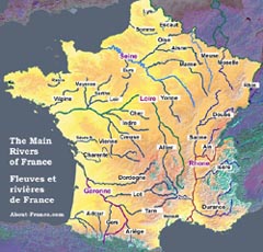
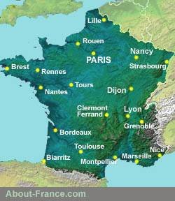
Map of the rivers of France. Click on the map for full-page version
About-France.com is an independent user-supported website that does not track visitors and carries very little advertising, Affiliate links to relevant partner websites may generate commission on sales at no cost to the user.
Click
here for more maps
of France, including a sunshine map
- Holiday
week planner
Avoid the busiest weeks; check out the Holiday planner. - Wild France - the parts for the outdoor enthusiast
- Long distance footpaths in France.
- Search for information about France
- River and canal touring in France