
Routes from Calais
Best routes from the Channel ports to the south and west of France
About-France.com
- the connoisseur's guide to France
- Explore France ►
- The essentials
- Travel in France
- Where to go
- What to see and do
Site
search
About-France.com
How to get through France avoiding the Paris area.
Click
any box for route guide and map....

Few things can be worse at the start of a long-awaited holiday, than being stuck for hours in a monstruous motorway traffic jam, rather than relaxing at one's holiday destination.
When travelling from the UK or from Belgium or Holland to anywhere in France, it is always best to avoid Paris, particularly during summer weekends.
The map above or left shows routes from Calais to most parts of France, avoiding Paris, and using motorways or dual-carriageways (divided highway) all or virtually all the way
There are two main routes south from Calais: the A16 motorway, via Boulogne, Abbeville and Rouen, and the A26 motorway via Arras and Reims (Rheims) .
The trunk roads marked in green are all dual carriageways; bear in mind that speed is limited to 110 km/h on dual carriageways, rather than the 130 km/h allowed on motorways.
The routes marked in grey are the main routes from Paris (which are liable to be very busy). Click to check out the busiest weeks for French road and holiday resorts
Through France to Spain
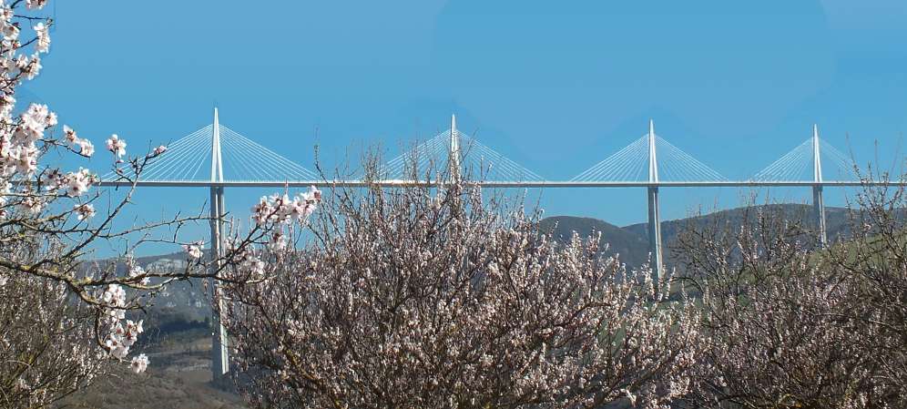
The map above shows the best England-Spain routes avoiding Paris. There are three possible Calais-Spain routes for traffic heading for the Mediterranean coast - Costa Brava, Costa Blanca and Andalucia. The route via Reims and Dijon is recommended for lorries and cars with caravans. The route via Clermont Ferrand, rising three times to over 1100 metres (about 3500 ft), crosses the Millau bridge, but includes some long and steep climbs. The route via Limoges is longer. More information on Routes to Spain.
Find
hotels
in France
Click
for best
online rates for hotels near the following towns on main motorway routes.
Reims
Dijon
Beaune
Lyon
Rouen
Orleans
Le Mans
Tours
Limoges
Poitiers
Bordeaux Clermont-Fd.
About-France.com
is
partnered with Europe's leading hotel booking portal, Booking.com, to
bring you the best online prices
Routes in brief
► via A16 To central southern & southwest France:
Follow: Boulogne > Abbeville > Rouen > Evreux > Chartres > Orleans...
!! Take care when leaving Calais if you use a satnav. Default routes will probably try to send you via Paris rather than via Rouen. So follow motorway signs for Boulogne, then Rouen, then Evreux and Orleans. Follow the roadsigns, not the satnav !
This is mostly on the N 154, which is almost all dual-carriageway as far as Chartres. Join the A10 motorway before Orleans.
Click for detailed A16 - A28 route guide and map.
► To southwest France:
Follow: Abbeville > Rouen > Le Mans > Tours...
As above as far as Rouen. After that, follow signs for Caen. Join the A13 motorway, then just west of Rouen branch off onto the A28 for Alençon and Le Mans.
Alternatively, take this route avoiding most or all tolls
► To western Normandy and Brittany
Follow: Abbeville > (Rouen) > Le Havre > Caen > Rennes...
Traffic for northwest France can actually avoid Rouen altogether by following Le Havre, then Caen, on the A 29 motorway that leaves the A 28 before Rouen.
► via A26 To Alsace, Switzerland, Alps, Provence:
Leave Calais on the A 26 motorway, following signs for Arras and Reims. After that, it is plain sailing all the way as far as Lyon or Strasbourg (via A4). Remember to take the A 39 motorway at Dijon, as this motorway is relatively traffic free; if you follow Beaune, you will soon join the very heavy traffic on the A6 Paris to Lyon motorway.
From the A39, you join the A 40, then the A 42. Before reaching Lyon, follow the signs for St Exupéry airport, then follow Marseille or Grenoble depending on your destination
Click for detailed A26 route guide and map .
South from Lyon:
Unfortunately (particularly on peak weekends in summer), there is no fast way of avoiding the A7 Rhone valley motorway if you are heading for Provence or the Riviera. The alternative is to take slow routes through the hills.
Driving through Rouen
lmportant! France has abandoned LEZ. Drivers going through Rouen therefore no longer need to have a Crit'Air emissions sticker. Rouen used to be a hassle, but the routes through the city are now clear, and mostly dual-carriageway... though liable to delays at rush hours.On entering Rouen, the A28 becomes the N28. Follow on down through the tunnels, then across the Seine.....
Then.....
► If heading for central southern France via Orleans get in the middle lane on the bridge over the Seine, then turn 270° right following the signs for Paris and Evreux. Join the Paris motorway, then branch right some 5 miles further, onto A154 for Evreux
► If heading for western or southwest France via Tours ,
get in the left-hand lane on the bridge over the Seine, then keep straight on following signs for Caen. Join the A13 motorway, then just west of Rouen branch off onto the A28 for Alençon and Le Mans for the southwest.
► Check
mileage from Calais to main centres in south and west France
► For routes in greater detail, click for A16 A71 A20 A10 N10 A26 A39 A7
Routes avoiding tolls:
► For routes in greater detail, click for A16 A71 A20 A10 N10 A26 A39 A7
Routes avoiding tolls:
► Click
here for route
to SW France avoiding tolls
► Click
here for route
to the Mediterranean avoiding tollsREMEMBER: when driving in France, follow Destination signboards rather than road numbers, except on motorways.
Other key driving pages :
- Driving in France - tips and information
- French rules of the road
- The A10 Paris - Tours - Bordeaux route
- The A4 Paris - Reims - Strasbourg route
- E19 - E44 Click for the route from Rotterdam and Brussels to Rouen and beyond
- General
motorway
and trunk route map of France
Contact
: Use the contact form from our site information web page.
Sorry but we cannot reply requests concerning individual travel plans.
Sorry but we cannot reply requests concerning individual travel plans.
Drivers with time to spare may
like to check out the new About-France.com pages on Byroads through
France
- a detailed route guide for a leisurely trip south from Rouen to the
Mediterranean, taking in lots of interesting places to see.
Paris tips
When to avoid Paris
It depends on your driving habits and skills.If you are not used to driving on the Continent, and not used to driving in heavy motorway traffic, avoid Paris at all times except nights between 10 pm and 6 am Monday to Saturday, and on Sunday morning and Sunday after 11 pm.
If you are happy driving in bumper-to-bumper motorway traffic, know the route and/or are using a reliable Satnav or GPS, then driving through Paris at these times may be no problem. On the other hand, you may well end up in slow-moving traffic. It is not uncommon for drivers to take the best part of an hour to get round half the Paris inner orbital motorway (the périphérique) instead of the 20 minutes needed if traffic is flowing smoothly.
A 86 Paris outer orbital motorway.
It is possible to come via the outskirts of Paris without needing to take the infamous "boulevard périphérique" inner ring road, by using the A86 outer orbital motorway. However, be warned: this route is NOT ACCESSIBLE to HGVs; don't even think of it! The northern part of the A86 is notorious for traffic jams, and the western part, the "A86 Duplex" runs for 10 km in a tunnel with a clearance of 2.5 metres. The route is not terribly easy to find from the south, and there is also a toll of 9 Euros. Given the steep toll, the tunnel section has remarkably little traffic.
From Calais go as far as Paris on the A16 via Amiens; in suburban Paris, follow A115 > A15 to interchange with A 86. The follow A 86 West, following signs for Nanterre then Versailles. After the 10 km of tunnel, leave on Exit 41 to N118 (dual carriageway) towards the A 10 motorway.
At most times of day, the tunnel carries very little traffic, on account of the high toll; so as long as you do not hit the Paris area at a time of day when other non-toll sections of the A86 are saturated (which is often the case) , this route may be faster than the route via Rouen.
Traditional
holiday gites in France
direct booking with owners mostly English speakers
Gitelink.com
direct booking with owners mostly English speakers
Gitelink.com
About us
An
independent website, About-France.com is an affiliate partner of other
selected travel service websites,
and may receive a small commission on sales generated after users click
through to a partner site.
Copyright texts and photos About-France.com