
The Dordogne valley
What and where is the Dordogne?
- Explore France ►
- Essential pages
- Travel in France
- Where to go
- What to see and do
About-France.com
- the connoisseur's guide to France
| Page index | |||
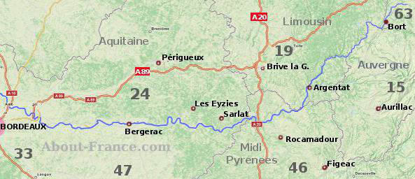
| The Dordogne department | Périgord Noir | The Lot | Corrèze & Limousin |
| Lot & Garonne | Quercy | Cantal and the Auvergne | |

What and where is the Dordogne, and why is it so popular ?
For a good many years, British travellers have been fascinated by, 'the Dordogne", an area of France that conjures up an image of a return to rural life at a slow pace; it has even been said that the Dordogne, for the English, is imagined not really as an area of modern France - which it is - but more as an imaginary reproduction of a bygone rural England - which of course it is not - rather like a warmer and sunnier version of the old Cotswolds, where the houses are built of honey-coloured stone, the meadows are green and rich, the locals all friendly and obliging country folk, and bemused French visitors can actually watch people playing cricket on the green - which indeed they can! Like Tuscany, the word Dordogne has become laden with bucolic symbolism and imagery to such an extent that it is useful to dig well below the surface and clarify what, exactly, the word "Dordogne" really means, and what this area really is.In fact, the word "Dordogne" has two different meanings. In the oldest sense of the word, it is a long river, a tributary of the Gironde, that rises in the Massif du Sancy in the Auvergne , flows down past Argentat, Bergerac, Saint-Emilion and Libourne, to meet the Gironde northwest of Bordeaux.
The second meaning of the word is a French department (county), the "Département de la Dordogne", surrounding a long stretch of the lower Dordogne between hills and plain.
Virtually the whole area is attractive hill country, full of old villages, castles, small country towns and plenty of scope for relaxing and enjoyable holidays. While the department of the Dordogne itself is increasingly geared to tourism, much of the area, particularly further into the hills, is very much "off the beaten track", and just waiting to be discovered.
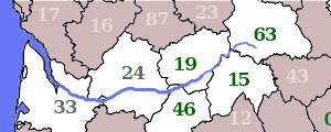
The department of the Dordogne (24)
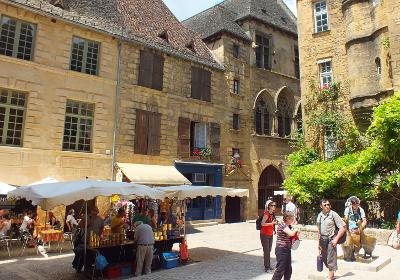 Old Sarlat
 A brand new authentic reproduction of the Lascaux caves, Lascaux 4, opened in December 2016, offering visitors a new and completely realistic visit indistinguishable in many ways from "the real thing".
There are other prehistoric caves that can be visited at Font de Gaume and Cap Blanc, and even a prehistoric theme park, Prehistoparc. Perigord Noir is not a mountain region; it is hill country, mostly at an altitude of between 200 and 350, metres.
West of Perigord Noir lies Périgord Pourpre, the area round Bergerac; this is a low lying area, the limits of the coastal plain, a region most famous for its wines and vineyards. As for the north of the department, this is known as Périgord Vert, Green Perigord, a greener and more undulating region of small villages and farms, streams and rivers.
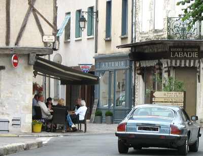 Eymet
Eymet It is essentially Périgord Pourpre and Périgord Vert that make up the "Dordogneshire" that has attracted such a lot of British expats. Small towns such as Belves, Mussidan and Eymet have an olde-worlde charm to them that is in marked contrast to the hustle and bustle of urban life in England or for that matter in big towns and cities anywhere. Yet the small towns of the Dordogne are in this respect much like many other small towns in rural France; in actual fact, the Dordogne is just one among several attractive rural departments in France. It just happens to have been singled out for special attention by the British.
As far as tourism is concerned, the department of the Dordogne has four very popular areas;
- Perigueux itself; the city has a beautiful historic centre, around its ancient Cathédrale Saint Front, one of the oldest in France (though rebuilt in the 19th century)
- The caves and prehistory area of the Vezère valley between Montignac, Lascaux and Les Eyzies
- The "medieval" city of Sarlat
- and the Dordogne valley itself, between Le Buillon and Aillac, an area including several of the finest of the Dordogne castles.
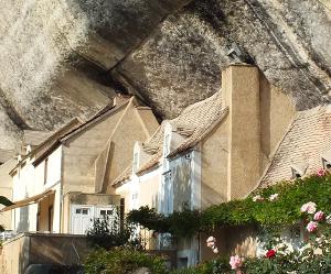
Old houses built under the overhang of a cliff, near les Eyzies. Men have lived in this area for around 400,000 years
For visitors who prefer to avoid the crowds,the Dordogne has several very attractive small towns that are worth visiting, but attract less tourists. These include Brantôme and Nontron, in the north of the department, Cadouin and Belves, south of Sarlat, and Eymet in the very south of the department. Away from the most popular sites, life moves at a slower speed.
As for the town of Bergerac, the local hub for this western part of the Dordogne, it is rather like any other town of its size in rural France, with its suburban sprawl, its superstores, its parking problems. Its small historic centre is attractive, but is not one of the unmissable sites to visit in the Dordogne area.
The rest of the Dordogne valley area.
 Upstream from the Dordogne
department, the hills get higher and the valley gets deeper. A
traveller moving upstream would reach, in succession, the following
departments, which are described in more detail below:
Lot, Corrèze,
Cantal,
and
finally the Puy
de Dome, in the Massif du Sancy, which is where the Dordogne begins its
journey to the sea.
Upstream from the Dordogne
department, the hills get higher and the valley gets deeper. A
traveller moving upstream would reach, in succession, the following
departments, which are described in more detail below:
Lot, Corrèze,
Cantal,
and
finally the Puy
de Dome, in the Massif du Sancy, which is where the Dordogne begins its
journey to the sea.The department of the Lot (46) and the Quercy area
The river Dordogne just passes through the northern tip of the Lot department; but this is a department that has also become very popular with visitors from Britain, Holland and other parts, and the Lot valley in particular has acquired an attraction of its own. Like the Dordogne, this is limestone country, and until recent years was actually more off the beaten track than the Dordogne. The department boasts one of France's major tourist attractions, the village of Rocamadour, perched up and down a steep cliff face overlooking the valley of the Ouysse. Like the Dordogne, the department has a number of spectacular underground caves, including the Gouffre de Padirac.
In the north west of the department, the land is higher, rising to 500 metres; but this is still delightful and soft countryside. The capital of the Lot is the beautiful small city of Cahors, famous for its medieval streets and its unique surviving 14th century bridge, the Pont de Valentré.
Cahors was once capital of a region known as the Quercy, which is nowadays made up of virtually the whole of the Lot department, plus part of the Lot et Garonne department to the south west. The name Quercy derives from the Latin word quercus, meaning an oak tree, and naturally this is a region rich in oak forests - not the massive oaks of old England, but smaller oaks of southern Europe. The Quercy is a limestone plateau, cut through by numerous streams and rivers. In the southeast, it extends into the popular Rouergue area and the Aveyron department. For further details and pictures, see Midi-Pyrenees region
The Department of Corrèze (19)
Before entering the Lot, the river Dordogne flows through the department of Corrèze, capital Tulle, which is administratively part of the Limousin region. We are now properly in the Massif Central mountains, and apart from the western tip of the department, most of the Corrèze lies between the altitudes of 600 and 800 metres. With higher hills, the climate is not so dry and hot in summer as the areas to the south west, and Corrèze boasts a fine collection of very beautiful small towns and villages, notably Collonges la Rouge - so named on acount of the red sandstone from which it is built - Curemonte and Turenne.
Cutting through the south west part of the department, the river Dordogne passes through some beautiful small towns and villages, such as Beaulieu and Argentat; and north of Argentat, the hills get higher and the valley deeper as the traveller enters the higher reaches of this river, the Dordogne gorges. From near its source in the Puy de Dôme, down as far as Argentat, the Dordogne has cut a deep valley through the mountains. Up above, the plateaux of the western Massif Central offer wide areas of upland farm country, fields and forests; this is a very rural area, largely off the tourist trail, and an area which tends to remain green all through the summer, even in the driest of years.
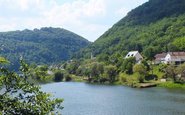
Spontour,
in the Corrèze department on the border with Cantal. The
upper Dordogne is in a deep valley, with a series of dams
The Cantal (15) and the Auvergne
For a distance of some 30 kms, the river Dordogne forms the border between the Corrèze and the Cantal departments, and thus between the Limousin and the Auvergne. The Cantal, capital Aurillac, really is mountain country, with peaks culminating at over 1800 metres. The Dordogne valley at this point is marked by a series of major dams, such as the Barrage de l'Aigle, providing hydro-electricity to the French grid for over 70 years . Behind the dams, in a steep wooded valley, the long lakes offer plenty of opportunity for water sports. The Cantal is reputed to be one of the coolest departments in France, which is not suprising since most of the department lies at over 800 metres; this is much appreciated by people who want to escape the dry heat of midsummer. The high peaks of the Cantal, consisting of a massive volcanic area, offer proper hill-walking country, as well as skiing in winter.
The source of the River Dordogne is in the neighbouring department of the Puy de Dome, at an altitude of almost 1800 metres, on the slopes of the Puy de Sancy, the highest peak in central France.
Copyright © About-France.com
About-France.com
Home
page - Site
search
- Regions
- Maps of France
- Contact
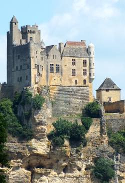
Castle at Beynac in the Dordogne valley
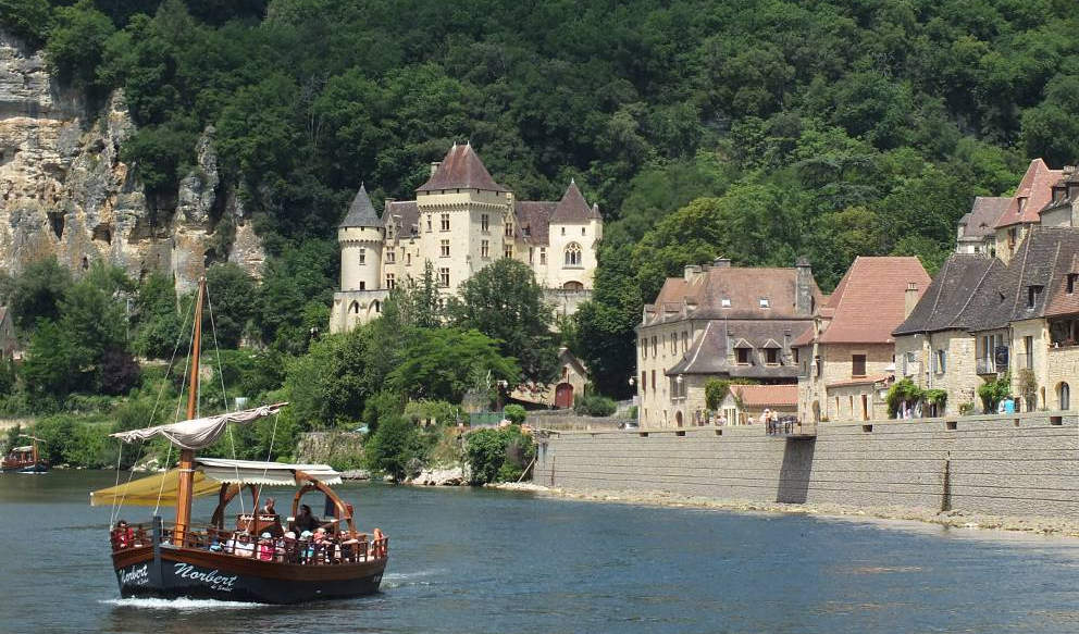
Photo top of page: La Roque Gageac.
The Dordogne is 483 km from its source to its mouth on the Gironde estuary, making it the third longest river in western France. Rising in the department of the Puy de Dome, in the mountains of the Auvergne, it flows down through the areas or regions of Auvergne, Limousin, Midi-Pyrénées and Aquitaine.
Compare
best car hire offers:
Click here to select airport or city
Click here to select airport or city
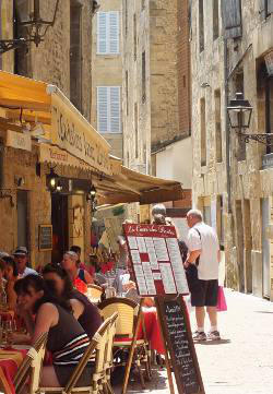
Restaurant in old Sarlat

Prehistoric cave paintings at Lascaux
Dordogne accommodation options
A
full range of hotels
in the DordogneSafe online booking at best rates
| ►► Site guide |
| About-France.com home |
| Full site index |
| About-France.com site search |
| ►► Principal chapters on About-France.com : |
| Guide
to the
regions of France Beyond
Paris, a guide to the French regions and their tourist attractions.
|
| Guide
to Paris Make
the most of your trip to Paris; Information on attractions, Paris
hotels, transport, and lots more.
|
| Accommodation
in France
The different options, including hotels,
holiday gites, b&b, hostels and more
|
| Tourism
in France
The
main tourist attractions and places to visit in France - historic
monuments, art galleries, seasides, and more
|
| Planning
a trip to France
Information
on things to do before starting your trip to France.
|
| Driving
in France
Tips
and useful information on driving in and through France - motorways,
tolls, where to stay....
|
| Maps
of France
Cities,
towns, departments, regions, climate, wine areas and other themes.
|
| The
French way of
life
A mine of information about
life and living in France, including
working in France, living in France, food and eating, education,
shopping.
|
| A-Z
dictionary of France Encyclopedic
dictionary of modern France - key figures, institutions, acronyms,
culture, icons, etc.
|
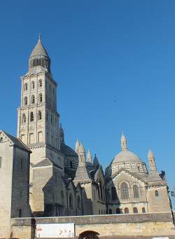
St Front's cathedral - Perigueux. The Byzantine-Romanesque tower is the oldest cathedral tower in France, nearly 1,000 years old
Texts and photos copyright © About-France.com
Map developed on a base from Openstreetmap.org