

Autun - Roman Augustodunum
Historic city in rural Burgundy
About-France.com
- the connoisseur's guide to France
Autun - off the beaten track in Burgundy
| On this page | Location and access | Sites and attractions |
| In the area | Hotels and accommodation ► |
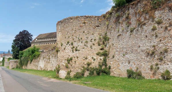
Autun has the most extensive Roman city walls in France
Located sixty kilometres from the Saône and 100 km from the Loire, well away from any significant modern route across France, Autun tends to get missed even by most of those who make a deliberate decision to visit Burgundy.
It was not always so. Two thousand years ago, the Romans fortified this hilltop, building a major oppidum known as Augustodunum, the city of Augustus, which soon rose in stature to become the second most important city in northern Gaul (Gallia Lugdunensis) after the capital Lyon. Augustudonum was a hub of culture and learning that was known across the Roman Empire, and it was very much on the beaten track, one of the key road hubs in Roman France. The size of the city's surviving Roman gates. bears witness to the importance of some of the roads that converged on this city.
Cassini's map of 1797 shows the main road from Paris to Lyon still passing through Autun, and in 1885, the city was chosen as home to one of France's six military academies. But away from the new lines of communication that developed in the railway age, and then the age of the motor car, Autun's fortunes waned, and the once powerful city became the small town that it is today.
The town
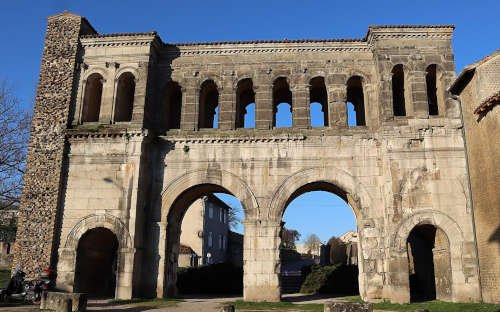
Imposing Roman Porte Saint-André
To see in Autun
1. Roman remains
- The city walls Over 4 km of Roman walls still survive in varying states of repair. The most impressive stretch runs north from the Tour des Ursulines, beside the Bvd. MacMahon.
- The city gates The Porte d'Arroux and the Porte Saint-André are two of the best preserved roman city gates in France .
- The Roman theatre. Built around 70 AD, this theatre was one of the largest in the Roman world, with a capacity in its heyday of up to 20,000 people.
- The Temple of Janus. Two of the four walls of this substantial Roman temple are still standing. The attribution to Janus is of dubious origin.
2. Other points of interest
- Cathédrale Saint-Lazare - Essentially built in the early tenth century, this has the finest romanesque tympanum of any French cathedral
- Musée Rollin - Near the cathedral, this small museum houses art and artefacts from the Middle Ages and the Renaissance
- Tour des Ursulines - The twelfth century octagonal keep of the former chateau that once stood beside the ramparts at the highest point of the town. The view from the top is superb.
- Passage Balthus - An unexpected Parisian-style mid 19th century city arcade, in the heart of old Autun, fully renovated in 2018.
- Temple Protestant - the oldest protestant church in France, next to the Roman Porte Saint André.
- Morvan Regional Park - The Morvan Regional Park in Burgundy is an exceptional area of forests, lakes and rolling green hills, much appreciated by hikers. The highest peak is the Haut Folin, at 901m (2956ft) above sea level.
- Chateau de Sully (20 km). Fairytale sixteenth-century castle, standing in the middle of a moat / lake - one of the most impressive châteaux in Burgundy
- Beaune and the Burgundy vineyards ( 50 km) Beaune is the capital of the Burgundy vineyard area, a UNESCO world heritage site.
- Mont Beuvray / Bibracte (26 km) - Culminating at 821 metres, Mont Beuvray is one of the highest peaks in the Morvan, and site of the historic Gaulish town of Bibracte. A museum inaugurated in 1995 is open from March to November, and the major archaeological site can be visited on foot.
- Vélorail du Morvan, at Cordesse. (12km). Enjoy a electrically-assisted pedal-cart ride along an abandoned railway line in the heart of the Morvan. Return routes 8.4 km or 22 km
- By air The nearest airports with international services are Paris Orly and Lyon Saint Exupéry
- By train There are no longer any train services to Autun. To reach Autun using public transport, take a local TER service from Dijon to Etang-sur-Arroux, and connect to a bus for Autun. There are also buses from Le Creusot TGV station, 40 km from Autun. For details check out Trainline.com .
- By car. From Paris, leave the A6 motorway at the A38 interchange, and after the tool booth take the D981 to Autun. From Beaune follow the D 973 westwards. From Nevers, on the Loire, follow the D978 via Chateau-Chinon.
Copyright
© About-France.com except where otherwise stated.
About-France.com
Home
page - Site
search
- Regions
- Maps of France
- Contact
Photo top of page : Sculped Tympanum of St.
Lazare's Cathedral
★★ Hôtel Jardins du Lac
Two-star hotel by the lake. Restaurant and free parking.
★★★ Hôtel Ibis
Three-star hotel between town and country. Free parking.
★★★ Villa Medicis
Three-star apartments in a historic building in the old town. Free parking.
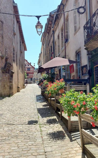
Street in the old part of Autun
About-France.com is a fully independent website affiliated to certain online booking platforms, and may receive a small commission only on bookings made through affiliate sites . This has no effect at all on the price paid by the visitor.
Copyright texts © About-France.com
Photos © About-France.com
except Porte Saint André - Creative Commons 2 photo by GO69.
.
Map by Openstreetmap. org
Where to stay
The About-France.com selection
Hotels for all budgets and all needs
Hotels for all budgets and all needs
★★ Hôtel Jardins du Lac
Two-star hotel by the lake. Restaurant and free parking.
★★★ Hôtel Ibis
Three-star hotel between town and country. Free parking.
★★★ Villa Medicis
Three-star apartments in a historic building in the old town. Free parking.
Check out other accommodation in Autun
Hotels, B&Bs, apartments, holiday homesStreet in the old part of Autun
About-France.com is a fully independent website affiliated to certain online booking platforms, and may receive a small commission only on bookings made through affiliate sites . This has no effect at all on the price paid by the visitor.
| ►► Site guide |
| About-France.com home |
| Full site index |
| About-France.com site search |
| ►► Principal chapters on About-France.com |
| The
regions of France Beyond
Paris, a guide to the French regions and their tourist attractions.
|
| Accommodation
in France |
| Guide
to Paris Make
the most of your trip to Paris; attractions,
Paris hotels,
transport, and lots more.
|
| Tourism in France
The
main tourist attractions and places to visit in France - historic
monuments, art galleries, and more
|
| Planning
a trip to
France
Information
on things to do before starting your trip to France.
|
| Driving
in France
Tips
and useful information on driving in and through France - motorways,
tolls, where to stay....
|
| Maps
of France
Cities,
towns, departments, regions, climate, wine areas and other themes.
|
| The French way of
life
A
mine of information about life and living in France,
|
| A-Z
dictionary
of France Encyclopedic
dictionary of modern France
|
Click here for
low-cost car hire in France
low-cost car hire in France
Copyright texts © About-France.com
Photos © About-France.com
except Porte Saint André - Creative Commons 2 photo by GO69.
.
Map by Openstreetmap. org