Climate and weather in France
France and its many climates
- Explore France ►
- Essential pages
- Travel in France
- Where to go
- What to see and do
About-France.com
- the connoisseur's guide to France
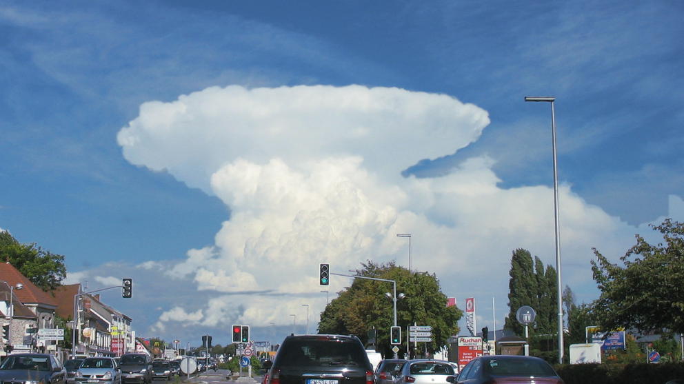
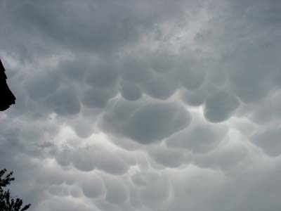
Photo
above : A
perfect thunderstorm builds up over Paris on a hot summer's afternoon🌞 Intense heat warning
Climate change is here to stay,and France, like other countries, is getting warmler, and subject to more extremes of temperature.2023 and 2025 were marked by very dry weather in many parts of France, right through to October. In 2023 an early- August heatwave lasted for 10 days, while most of France benefited from record warm days through until mid-October, with September highs of over 30° in most of the country, and early October highs of over 30° in much of the south.
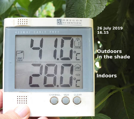
2019, then 2020, then 2022 all broke the record with maxima in excess of 40° Celsius (105° F) in many cities, including Paris, Strasbourg, Lyon, Reims, Tours, Bordeaux, Toulouse and many more parts. Maxima of over 43° have been recorded in many places in the south of France, with a peak of 46.0° near Nîmes on 28th June 2019, the hottest temperature ever recorded in France.
As the climate continues to change, meteorologists expect 40° temperatures to become a regular though occasional feature of summer days in the south of France.
Photo: no longer a rare sight in France.....


Like many places on Earth, France has weather conditions that are strongly influenced by barometric pressure: low pressure tends to leave France open to the influence of the Atlantic airstream, bringing with it clouds and rain; but when a ridge of high pressure builds up over the heart of western Europe, a large part of France, sometimes even the whole country, can be protected from the prevailing westerlies under a vast covering of dry air, often accompanied by winds from the east.
 In short, the weather
in France is determined by the balance of power
between oceanic weather systems from the west, and continental
anticyclones from the east.
In short, the weather
in France is determined by the balance of power
between oceanic weather systems from the west, and continental
anticyclones from the east. It is the differing relative influence of these systems that determine the two main climate zones of France, and within these two zones the different sub-zones.
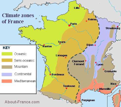
These zones can be seen in the map on the left. In the western and north-western half of France, stretching from the Belgian border to the Pyrenees, the climate is generally oceanic, In Atlantic and northern regions, the influence of Atlantic weather systems is predominant; but further south and east, the influence of Atlantic weather systems diminishes. The zones on the map are not fixed: the map shows the dominant type of climate over the year, but borders can move. For instance when strong weather systems move in from the Atlantic, virtually the whole of France enjoys (or otherwise, as the case may be) an oceanic climate.
In practical terms, this means that the western areas of France benefit from a mild climate, with moderate rainfall possible at all times of the year. The "oceanic" area, and notably Brittany, jutting out into the Atlantic, has a particularly mild climate, but can be quite rainy even in summer months - though this is not always the case by any means. The semi-oceanic area, also called the intermediate area, has less rainfall particularly in summer, as it is more often under the influence of continental high-pressure systems. This band includes the great cereal growing regions of France, Champagne, the Beauce (south of Paris) and the Midi Pyrenees area round Toulouse.
The eastern side of France has a more continental climate, Apart from the mountain areas, it is generally drier than western France, with winters that are colder and summers that are hotter, for a given latitude, The south coast of France benefits from a continental climate moderated by the influence of the Mediteranean, generally drier than the rest of France, and without the cold winters of the rest of the continental climate zone.
The official French weather forecast site can be found at meteofrance.com .
Winds of France
The climate of eastern and southern France is particularly influenced by the nature and direction of the wind- La Bise is the dry east wind that can blow over from central Europe; in winter it can be bitterly cold, in summer blisteringly hot. Blocked over France by the Atlantic weather systems and by the Massif Central
- Le Mistral. Le Mistral is a prolongation towards the south of La Bise, a dry wind that blows down the Rhone valley to central Provence for weeks on end, and in winter can be surprisingly cold.
- Le Tramontane .This is the wind from the north that skirts round the Massif Central or blows over the top of it towards the Mediterranean.
- Le Vent d'Autan is a wind that blows up from the Mediterranean, and over towards Toulouse and Bordeaux . It can bring very warm weather in the Autumn, and cause heavy rainfall if the air is humid.
The microclimate of the Riviera: the extreme southeast of France, the area around Cannes, Nice and Monaco, benefits from its own microclimate; protected from the Mistral by the mass of the Alps, the climate on this narrow coastal plain is pure Mediterranean, with mild winters and warm summers.
 The mountain areas of France;
like all mountain areas, France's mountain areas have a cooler climate
than surrounding areas, with more precipitation. Since the wet winds in
France are those that come from the west or to a lesser extent from the
south, it is the southern and western sides of the mountain ranges that
are wetter. This is particularly the case with the Massif Central,
whose eastern half is drier. The Cevennes mountains, the south eastern
part of the Massif Central, are generally quit dry, but can receive
deluges of heavy rain if wet air moves up from the Mediterranean, which
happens most often in the Spring or Autumn.
The mountain areas of France;
like all mountain areas, France's mountain areas have a cooler climate
than surrounding areas, with more precipitation. Since the wet winds in
France are those that come from the west or to a lesser extent from the
south, it is the southern and western sides of the mountain ranges that
are wetter. This is particularly the case with the Massif Central,
whose eastern half is drier. The Cevennes mountains, the south eastern
part of the Massif Central, are generally quit dry, but can receive
deluges of heavy rain if wet air moves up from the Mediterranean, which
happens most often in the Spring or Autumn.  During
summer, the upland areas of central southern France are generally warm
and sunny, but dramatic skies can brew up on sultry summer afternoons,
often developing into short but spectacular thunder storms.
During
summer, the upland areas of central southern France are generally warm
and sunny, but dramatic skies can brew up on sultry summer afternoons,
often developing into short but spectacular thunder storms. In the Pyrenees, it is the French side of this range, i.e the north eastern side, that is wetter than the Spanish side. This is because moist oceanic air is pulled through southwest France from the Atlantic to the Mediterranean. In all the mountain areas of France, thunderstorms are a common feature in summer.
Moving Boundaries:
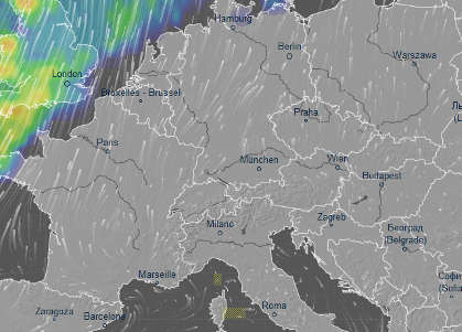
Sometimes high pressure systems will protect the whole of the continent from Atlantic low-pressure systems with their wind and rain (coloured areas). Image from Ventusky.com
With the exception of the areas of mountain climate, which are determined largely by altitude and topography, the borderlines betwen the different climate zones of France are variable, and will move north and south, east and west, depending on the strength of conflicting weather systems. It is quite possible for the whole of France to come under the influence of the prevailing Atlantic westerlies, with their clouds and showers; conversely at other times the whole of France can be dominated by continental air masses, leaving hardly a cloud in the sky over the whole country.
FRENCH WEATHER CHAOS since 2012
2012 was marked by an exceptionally could spell in mid February, lasting two weeks, that affected almost the whole country. For several days, virtually the whole of France lay under snow, and temperatures fell to below -10°C in much of southwest France, and considerably colder in more traditionally cold areas. In Paris, the lakes in the Bois de Boulogne froze solid, enough for people to walk on the ice (strictly forbidden, of course). Then, a month later, most of southern France enjoyed over a week in March with daytime temperatures in the high twenties - more like June - though June itself was remarkably damp and cool. Not so July, when several parts of southern France recorded afternoon temperatures over 40°C, with 43° being recorded in the middle of Clermont Ferrand at the hottest moment...
2016 - the year it rained...
Not everywhere in France, but over a good part of northern and western France, Spring brought torrential rainfall and flooding to much of France. In particular, the Loire valley saw extensive flooding which led to the very busy A10 Paris-Bordeaux motorway being cut for ten days. Many farmers in the region lost a good proportion of their crops. It was not until mid July that normal summer weather broke out. After that, there were plenty of sunny and warm days, with the occasional short heatwave of the type that is now becoming familiar each summer, with temperatures hitting the 40°C in several parts of the south of France
Autumn brought its traditional episodes of monsoon-type rain in the south of France, notably on the Cevennes.
2019 - the hottest ever
And 2019 was the hottest ever summer recorded in France - as in much of Europe.
2021 - 2025 - records keep falling
Many parts of France recorded their highest ever March temperatures in 2021, and also some record lows in April, a combination that caused havoc in orchards and vineyards in many areas. Though the summer of 2021 was hot, few summer heat records were broken; it was not until the end of the year that the record-keepers turned to their notebooks again, as temperatures on New Year's Eve shattered previous records in many parts of France in a relative but short lived heatwave that continued into the first days of January, before conditions returned to normal.
September 2023 was the hottest on record, and record October temperatures were smashed on Oct. 2nd by over 5° in some places.
About-France.com
Home
page - Site search
- Regions
- Maps of France
Atlantic,
continental or Mediterranean, the French climate is remarkably
diverse. This short guide outlines the normal climatic factors in
different parts of France, and traditional French weather patterns.
Other holiday planning pages.... Prepare your holiday in France, decide when and where to go, what to take with you, where to stay and how to get there.
Other holiday planning pages.... Prepare your holiday in France, decide when and where to go, what to take with you, where to stay and how to get there.
About-France.com
is an
independent website that does not track users and does not show any
personalised advertising, About-France.com uses affiliate links to
selected relevant external partner websites,
and may receive a small commission on sales or bookings generated on
these sites.

The A75 motorway, at an altitude of about 1000m, in mid winter... after the snow-ploughs have been busy.