Tour de France 2024 - stage 11
Detailed stage map
- Explore France ►
- Essential pages
- Travel in France
- Where to go
- What to see and do
About-France.com
- the connoisseur's guide to France
Map:
click on icons for more information. 
Evaux les Bains (Creuse) to Le Lioran (Cantal)
Day 11 is mountain day.... . Starting from the small town of Evaux les Bains, in the Creuse department of the Limousin area, riders pedal south towards the highest peaks of the Massif Central, for a finish at the ski resort of Le Lioran in the Auvergne. The first hundred kilometres of the journey are relatively uneventful, and the peloton will make good speed over the country roads heading due south towards the distant peaks. The 786 m col at Laroque is the highest point of the first half of the race.South of the village of Messeix, on the D73, the route crosses the river Dordogne, still little more than a stream. The Dordogne is a lot more impressive by the time it reaches Bort les Orgues, where it forms a long lake behind the first of the many Dordogne dams that generate hydroelectricity for the French grid. The "organs" at Bort are not musical instruments, but impressive displays of basalt organ rocks, which are quite common in this volcanic part of France.
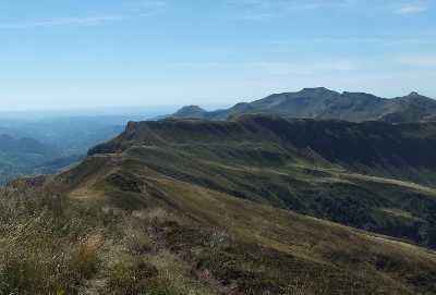
From Bort, riders climb out of the Dordogne valley and on southwards in the direction of Mauriac, before turning off at Le Vigean, towards the Massif du Cantal. The route follows the valley of the Mars as far as le Falgoux, after which the proper climbing begins. After the Col de Néronne at 1242 metres, it's on and up to the dramatic Pas de Peyrol which, at 1589 metres, is the highest road pass in central France. From there it's down again, then back up to the Col du Perthus at 1309 metres, before dropping down to Saint Jacques de Blats in the valley of the Cère, before the final climb to Le Lioron. At the top of the climb, riders do not take the road tunnel, but take in the extra metres to the old pass at the Col de Font de Cère, before dropping down to the finish in the ski resort just below.... a resort at the foot of the Plomb du Cantal, which at 1,855 metres, is the second highest peak in the Massif Central.
► See stage 12 route map
About-France.com
Home
page - Regions
- Maps of France
- Contact
Site
search
About-France.com
What are you looking for ? Where do you want to go?
About-France.com
What are you looking for ? Where do you want to go?
From the Creuse to the Cantal
Stage 11, on Wednesday 10th July 2024, takes riders on an almost due south route through the northern slopes of the Massif Central, for a finish atthe winter sports resort of le Lioran
Viewl towards the Puy Mary.
An
independent website, About-France.com is an affiliate partner
of
selected travel service websites,
and may receive a small commission on sales generated after users click
through to a partner site.
Text Copyright © About-France.com 2007 - 2024
