
The French Pyrenees
A short
guide ~
from the Atlantic to the Mediterranean
- Explore France ►
- Essential pages
- Travel in France
- Where to go
- What to see and do
About-France.com
- the connoisseur's guide to France
A short guide to the French Pyrenees from the Atlantic to the Mediterranean
For more detail, see Languedoc
and Midi-Pyrenees
and Aquitaine area pages
► See also; specific guides: The Yellow Train Prehistoric France Cathar country The Tour de France in the Pyrenees
► See also; specific guides: The Yellow Train Prehistoric France Cathar country The Tour de France in the Pyrenees
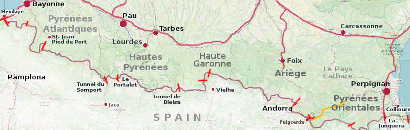
| Page index | Area overview | Main tourist attractions | Main cities |
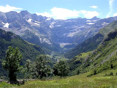 The
Cirque de Gavarnie in the High Pyrenees National Park
The
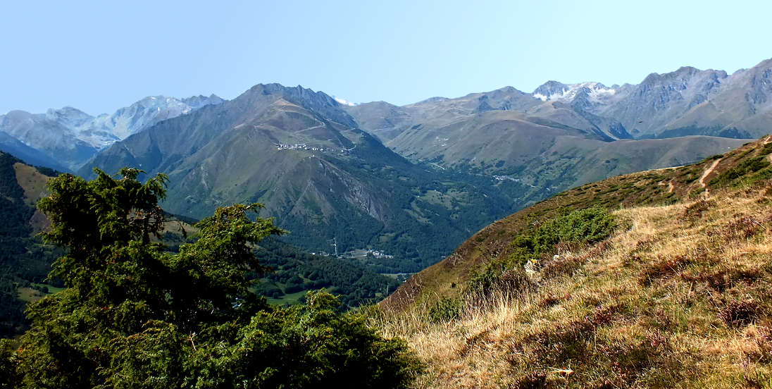
Cirque de Gavarnie in the High Pyrenees National Park Of all the world's natural frontiers, the Pyrenees make up one of the most clearly defined. Stretching coast to coast from the Atlantic Ocean in the west to the Mediterranean in the east, they form a natural barrier between France and Spain which – until modern times – was unpassable for several months of the year except by one route on the Atlantic coast and a couple more very close to the Mediterranean.
Between these coastal routes, the Pyrenees rise up to heights of over 3000 metres (10,000 ft) above sea level, and are crossed by only a small number of passes many of which, even today, can be blocked by snow in winter time, in spite of some high-altitude tunnels. In the nineteenth century, rail connections between France and Spain (albeit no direct trains, due to Spain's use of a wider track gauge) were established right beside the sea on the Atlantic and Mediterranean coasts; two more rail routes across the Pyrenees were set up later, but they remained branch lines and one of them has since closed.
In short, for the last few centuries, the Pyrenees have effectively been a natural barrier separating France from Spain, and seriously limiting communication and exchanges between the two neighbouring countries.
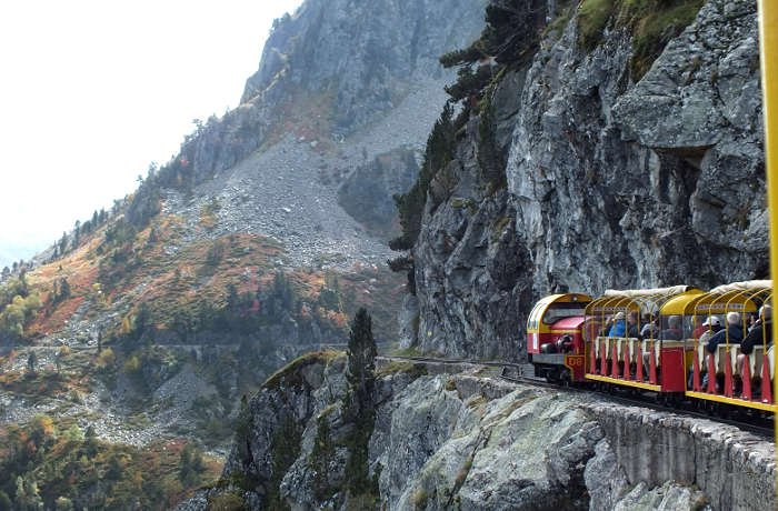
The Train d'Artouste, in the western Pyrenees
This early division among different ethnic and cultural groups explains why, today, the Pyrenees retain greater differences between their eastern and western halves, than they do, at any crossing point, between the French and the Spanish sides. The French Basque Country is remarkably similar to the Spanish Basque country, and the same Basque language is still used by some throughout the area, though not as an official language in France. On the east coast, there is a strong Catalan identity in the department of Eastern Pyrenees. In the central Pyrenees, while the landscape may be more arid and less green on the Spanish side, villages and traditional building styles are much the same in France and Spain.
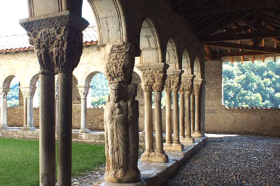
Romanesque cloister at
Saint Bertrand de Comminges
After the Santiago pilgrimage route fell largely out of fashion in the 18th century, religion once again put the Pyrenees firmly back on the map in the mid 19th century after a shepherdess called Bernadette Soubirous, in search of a lost sheep, claimed to have encountered the Virgin Mary in a grotto near the village of Lourdes. Today, Lourdes is one of the three great Catholic pilgrimage sites in Europe, with some 5 million visitors a year.
Geography and climate
The French Pyrenees are located mainly in the Occitanie region of France (in the former regions of Languedoc and Midi-Pyrenees ).On the French side, the Pyrenees rise up fairly steeply from the low-lying land of the Garonne and Adour basins in the west (Gascony), and from the lowlands of the Aude in the east. The foothills are fairly well wooded, with deciduous forests and farmland. Towards the Spanish border, as the land reaches altitudes of 1500 metres and higher, the woods and forests give way to moorland that provides summer grazing land for cattle and sheep, and plenty of opportunity for hiking.
The best opportunities for serious mountain hiking and mountaineering in the French Pyrenees are to be found in the department of Hautes Pyrénées, and notably in the area of the Pyrenees National Park, where much of the land is at more than 2500 metres, culminating in the Pic de Vignemale at at a height of 3298 metres (10,820 ft) on the Spanish border. Vignemale is one of three peaks at over 3000 metres in the French Pyrenees or marking the border with Spain. The highest point in the Pyrenees is the Pico d'Aneto which lies in the Ordesa national Park in Spain.
With most valleys in the French Pyrenees running south-north, east-west routes involve numerous mountain passes at altitudes of over 1400 metres, very popular with cyclists. The highest of these is the 2115 metre Col du Tourmalet, some 50 km to the south of Tarbes, which features regularly in the Tour de France.
Right at the eastern end of the Pyrenees, the Massif des Albères, peaking at 1256 metres, is an area of typically Mediterranean hinterland, with dry scrubland and wooded slopes.
In terms of climate, the French Pyrenees are subject to two main influences; warm winds from the southwest, and Atlantic winds from the northwest. Thanks to the winds from the southwest, the French side of the Pyrenees are often the warmest area in France, specially in spring and autumn; but when the winds veer to the northwest, days are more likely to be damp and rainy – a factor that explains why Pyrenean valleys on the French side tend to remain lusciously green through much of the summer. For much of the summer however and parts of the winter, when high pressure systems dominate over southern France and Spain, the weather in the Pyrenees is likely to be sunny and dry.
The department of the Eastern Pyrenees (Pyrénées Orientales) is the warmest and most southerly department in France, famed for its early spring and its orchards. The area round the small town of Céret, in the Tech valley, is reputed for producing the first cherries of the year which ripen in late April.
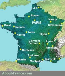
Main cities:
Perpignan, Pau, Tarbes, Bayonne; and just to the north, Toulouse, capital of the Occitanie region.
Tourist attractions in the French Pyrenees
Historic monuments in the Pyrenees and their foothills► Best prehistoric sites
- Mas d'Azil (Ariège) - a remarkable drive-through cavern with prehistoric site and museum
- Grotte de Thiau (Ariège) - one of the few caves with original prehistoric art that is open to the public
- Grotte de Gargas (near Saint Gaudens, Haute Garonne) - another prehistoric cave with underground visits, and the largest number of prehistoric hand symbols in Europe.
► Best mediaeval sites.
- The Cathar castles (PO and Ariège)
- Arles sur Tech. (PO, west of Perpignan) Abbaye Ste. Marie, Romanesque church with frescoes, and fine 14th century cloisters
- Elne (PO, southeast of Perpignan). A romanesque cathedral with tower and cloisters.
- Saint Michel de Cuxa (PO). Abbey church, tower and cloisters dating from 10th to 12th centuries, fine sculptures
- Saint Martin du Canigou (PO) another beautiful romanesque abbey from the XIth century.
- Serrabona Priory (PO), former priory with romanesque church and cloisters, now a museum with large botanical gardens.
- Foix (Ariège) Fine medieval castle on a rocky outcrop in the town. Lots of steps up.
- Saint Lizier (Eastern Ariège, near Saint Girons) - Historic small city - Romanesque cathedral and cloisters, with fine 11th century frescoes. UNESCO listed site
- Saint Bertrand de Comminges (Haute Garonne, near Saint Gaudens) Hilltop town, church and monastery with romanesque cloisters- UNESCO listed site
- Luz Saint Sauveur (Hautes Pyrénées) Fortified medieval church of the Knights Templar.
- Morlaas (Pyrénées Atlantiques) Church of Sainte Foy, with very fine romanesque sculptures.
► Best small towns to visit
- Eastern Pyrenees : Collioure, Céret (with famed modern art museum) , Elne, Villefranche de Conflant : historic villages : Castelnou
- Ariège : Foix
- Pyrénées Atlantiques : Saint Jean de Luz - former fishing village on the Atlantic coast.
► Natural sites:
Virtually the whole of the French Pyrenees and their foothills are an outstanding natural site, and listing every specific site would take an encyclopaedia. So here is just a short selection of sites that are worth going out of one's way to visit.- Grottes de Betharem (on the border between Hautes Pyrenees and Pyrenees Atlantiques): 2.8 km of underground caves to explore by foot, train and boat.
- Gorge de Galamus (PO) - a road takes visitors through a very narrow gorge with sheer sides
- Cirque de Gavarnie (Hautes Pyrénées) ; the most dramatic site in the Pyrenees National Park, a narrow valley enclosed by rock faces up to 1500 metres high. La Grande Cascade de Gavarnie is, with a drop of 422 metres, the second highest waterfall in Europe.
- Pic du Midi - (Haute Pyrénées) . Take the cablecar from the base station at La Mongie, to the observatory at the top of the mountain, at an altitude of 2,872 metres. Note: not cheap. Adult rate (2019) : 45 €
► Miscellaneous:
- The narrow-gauge Train Jaune, or Yellow train. (PO) A historic electric train service from Villefranche-Vernet-les-Bains to Latour de Carol
- Le Petit train d'Artouste. Near Laruns (Pyrénées Atlantiques). A six km train journey on a former narrow-gauge industrial railway at an altitude of almost 2000. metres. Access by cablecar.
► Skiing in the Pyrenees
There are half a dozen major ski-resorts in the French Pyrenees, and more on the Spanish side, including the slopes in the Val d'Arun which, though in Spain, are more easily accessible from the French side of the Pyrenees.► Accommodation:
| Site guide .... | The French way of life | Tourism | Maps of France |
| Visiting France | Paris | Driving in France | Regions of France |
About-France.com
Home
page - Site
search
- Regions
- Maps of France
- Contact
A short
guide to the French Pyrenees, from the Atlantic to the Mediterranean -
natural and historic heritage, sites and other
points of interest.
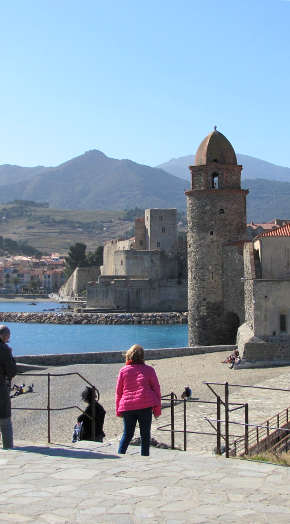
Collioure, where the Pyrenees meet the Mediterranean
The Pyrenees from end to end
Travelling the full length of Pyrenees makes for an interesting (and often energetic) trip on foot, by bike, by motorbike or by car.For the most hardy adventurers, French long-distance hiking trail (Sentier de Grande Randonnée) GR 10 runs all along the Spanish border from Hendaye on the Atlantic to Banyuls on the Mediterranean, a distance of 1,015 kilometres. The hiking trail has plenty of ups and downs, with the highest point being the Hourquette d'Ossou at 2,734 metres altitude. For obvious reasons, the high parts of this hiking trail are summer-only, as for much of the year they will be above the snow-line.
The hardiest of hikers can even make a round trip, going one way on the French trans-Pyrenean trail, and the other on the Spanish GR 11, on the other side of the border. For more on French hiking trails see Hiking in France
For visitors on two wheels or four, the classic trip involves taking the former N 618, the national route that used to link Saint Jean de Luz on the Atlantic with Argeles on the Mediterranean. Today the RN 618 has been downgraded (though its upkeep has been improved), and it has become the D 918 in the west and the D 618 in the east. This road takes travellers over many of the famous Pyrenean passes that feature regularly on the itinerary of the Tour de France, including the Cols of Aubisque, Peyresourde, Tourmalet and Portillon. It includes a brief section in Spain. Detailed route on Wikipedia.
Across the Pyrenees to Spain
The easiest crossings are those on the French A63 motorway on the Atlantic coast, and the French A9 motorway at Le Perthus, on the Mediterranean route.All other crossings are mountainous, particularly those in the middle which - even where there are tunnels - involve hairpin-bend climbs to a height of well over 1000 metres.
Roads up to and down from Andorra are good, but involve climbing to over 100 metres. The crossing from the north towards Vielha allows entry into Spain without crossing the Pyrenees. The Spanish town of Vielha is in an area known as the Val d'Arun, which is actually the high valley of the river Garonne, which flows down to Toulouse and Bordeaux. However while there are no passes to cross before Vielha, there are passes to cross south of the town, and while both have tunnels, they still require climbing to well over 1000 metres
Click here for
low-cost car hire in France
low-cost car hire in France
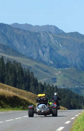
The Pyrenees are popular with bikers and cyclists
Website text and photos © copyright About-France.com unless otherwise stated
An
independent website, About-France.com is an affiliate partner of
certain travel service websites,
and may receive a small commission on sales generated after users click
through to a partner site.