French mileage chart - in miles
Distances
between main points in France
About-France.com
- the connoisseur's guide to France
- Discover France ►
- Essential pages
- Travel in France
- Where to go
- What to see and do
You may also like ►.
Routes through
France to Spain - options and distances
| ► Other travel pages and topics ........ click for: | ||||
| French motorway tolls | Road numbers and roadsigns | Avoiding Paris | Avoiding heavy traffic | Filling up |
| French motorway service areas | Speed limits & cameras | Routes from Calais | HGV restrictions | Accidents |
Overnight accommodation:
► Find hotels close to French motorway exits: route maps and hotel details on these routes :
| Routes
to southwest |
Routes via Rouen | A10 Paris-Bordeaux | To southeast: | A26 - routes via Reims |
Find
hotels
in France

Click for best online rates for hotels near the following towns on main motorway routes.
Calais
Reims
Dijon
Beaune
Lyon
Rouen
Orleans
Tours
Limoges
Poitiers
Bordeaux Clermont-Fd.
Click for best online rates for hotels near the following towns on main motorway routes.
Reims
Dijon
Beaune
Lyon
Rouen
Orleans
Tours
Limoges
Poitiers
Bordeaux Clermont-Fd.
About-France.com
is
partnered with Europe's leading hotel booking portal, Booking.com, to
bring you the best online prices
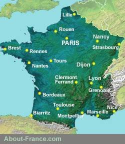
Distances between main points in France
Use this table to check distances in miles between the main entry points into France (Paris, Calais, Cherbourg, Roscoff, Strasbourg, etc.), in the north and east of the country, and the main cities and centres in the south and west of France.
- Vertical columns: distances from the nine principal entry points into France (cities on or near the border)
- Horizontal lines: the main regional centres and significant points in the south and west of France.
Figures in red indicate the channel port from which the journey distance is shortest for a given destination; but depending on the destination, the difference may not be very great. For instance, for driving to Perpignan (and on to the Costa Brava or Costa Blanca) the difference is minimal.
Ferries : About-France.com strongly recommends booking ferries directly from ferry companies. Prices are usually the same as from so-called "cheap" ferry ticket outfits; and changing or exchanging a ferry booking is liable to be much easier and cheaper if you have booked directly with the ferry operator. No-one plans to have to change their booking, but many end up doing so......
| Paris | Calais* | Cherbourg | Roscoff | Lille | Luxem bourg | Strasbourg | Mulhouse | Geneva | |
| Paris | 181 | 220 | 348 | 138 | 228 | 304 | 228 | 365 |
|
| Biarritz | 487 | 667 | 534 | 527 | 621 | 712 | 728 | 655 | 563 |
| Bordeaux | 368 | 542 | 410 | 403 | 504 | 588 | 604 | 532 | 443 |
| Brest | 368 | 446 | 263 | 40 | 473 | 590 | 666 | 677 | 676 |
| Clermont-Fd | 263 | 442 | 446 | 500 | 398 | 391 | 376 | 318 | 201 |
| Dijon | 194 | 356 | 415 | 515 | 312 | 203 | 207 | 139 | 163 |
| Lyon | 289 | 474 | 509 | 608 | 430 | 322 | 303 | 239 | 93 |
| Marseille | 482 | 671 | 707 | 750 | 624 | 515 | 504 | 434 | 286 2 |
| Nantes | 237 | 371 | 210 | 195 | 372 | 459 | 538 | 537 | 485 |
| Nice | 584 | 774 | 810 | 890 | 730 | 496 | 483 | 426 1 | 332 3 |
| Perpignan | 528 | 687 | 685 | 694 | 666 | 600 | 588 | 519 | 371 |
| Toulouse | 420 | 600 | 555 | 564 | 556 | 498 | 604 | 536 | 425 |
* From Calais. Check out the About-France.com guide to routes from Calais
Don't underestimate distances: Calais to Perpignan is about the same distance as London to John o'Groats. Calais to Nice is a hundred miles more.....
Notes:
1. Mulhouse - Nice route is via Zurich & Milan
2. Geneva - Marseille, via Valence
3. Geneva - Nice route via Mont Blanc tunnel & Italy
1. Mulhouse - Nice route is via Zurich & Milan
2. Geneva - Marseille, via Valence
3. Geneva - Nice route via Mont Blanc tunnel & Italy
French motorway tolls:
 Most
French motorways are toll routes - and it is worth taking them
unless you have all the time in the world to wander along other routes
and avoid the tolls.
Most
French motorways are toll routes - and it is worth taking them
unless you have all the time in the world to wander along other routes
and avoid the tolls. In 2026, the average toll price in France for cars (Class 1) is about € 0.15 per mile (a little under €0.10 per km).
The price per kilometre varies from toll motorway to toll motorway,
For all but the smallest RVs (motorhomes or campervans), and for caravans, tolls are 50% more expensive, so there is perhaps more justification for avoiding the toll routes. But even then, not always.
- Check out here for toll costs on principal holiday routes through France.
- Check out these pages for no-tolls
routes to
southwest France and no-tolls
routes to
Provence.
and - About-Spain.net - map of toll and free motorways in Spain
► Journey times: taking into account stops, hold-ups and traffic conditions, an average speed of 60 m.p.h is feasible on a normal day on the French motorway system. Most of the long journeys across France will be fully, or very largely, on motorways or roads of motorway standard. On Saturdays in the summer, average speed may be only 50 mph or 55 mph depending on the route and the trafic density.
So to calculate the time needed, divide the mileage by 60 or 50, depending on when you plan to travel. Thus, the 600-mile journey from Calais to Toulouse should take about 10 hours under normal driving conditons, but could be up to 12 hours on a Saturday in summer.
Other useful sites:
- For information on travel in Spain, visit the About-Spain.net Driving in Spain page
About-France.com
Home
page - Site search
- Regions
- Maps of France
All photos
© About-France.com
Click
here for maps
of France, including a sunshine map
- Holiday
week planner
Avoid the busiest weeks; check out the Holiday planner. - Busiest weekends on the roads - avoid the jams
- Wild France - the parts for the outdoor enthusiast
- Long distance footpaths in France.
- Search for information about France
- River and canal touring in France
About-France.com
is an independent user-supported website that does not track visitors
and carries very little advertising, Affiliate links
to relevant
partner websites may generate commission on sales at no cost
to the
user.